
Amendment Commences 27 January 2025
The guidelines for development and operation of enrolment schemes are issued under Schedule 20, Clause 3 (3) of the Education and Training Act 2020 for the purpose of describing the basis on which the Secretary’s powers in relation to enrolment schemes will be exercised.
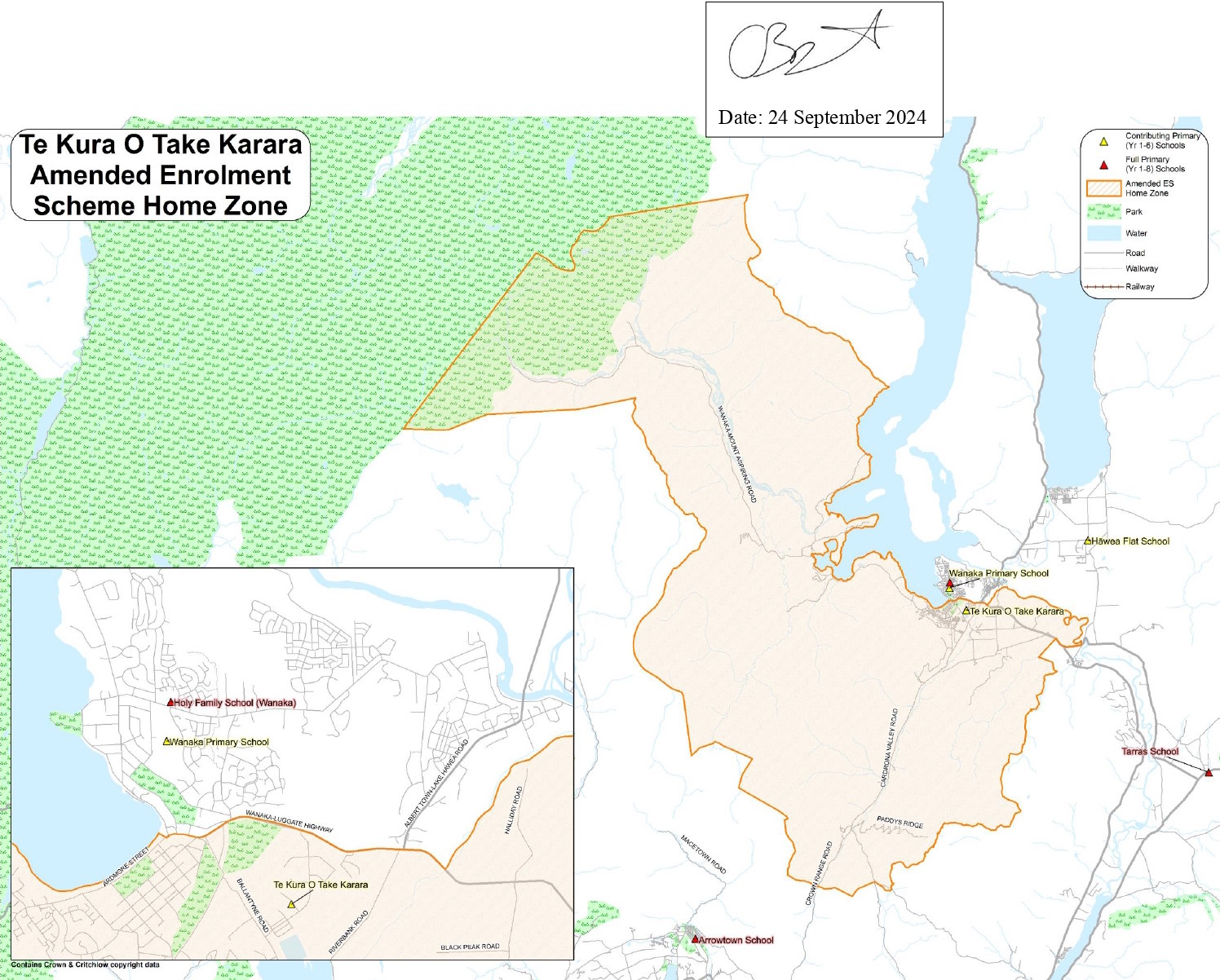
All students who live within the home zone described below (and shown on the attached map) shall be eligible to enrol at the school.
The Home Zone takes addresses on both sides of the boundary roads mentioned in the description unless otherwise stated.
Starting from the northern end of Wanaka-Mount Aspiring Road, near Mount Aspiring National Park, the home zone follows:
For families of currently enrolled students whose addresses become out of zone as a result of the amendment to this Enrolment Scheme.
Section 75 of the Education and Training Act 2020 states that; “the Secretary may authorise an enrolment scheme to permit a student to enrol at the school as if the student lived in the home zone of the school if, –
(a) in the case of an existing enrolment scheme whose home zone is amended, —
(i) the student lives outside the amended home zone; and
(ii) the student has a sibling who is enrolled at the school at the time that the amendment is implemented; and
(iii) the sibling, at the time that the amendment is implemented, lives inside the home zone as it was before the amendment; and
(iv) the student, at the time of enrolment, lives inside the home zone as it was before the amendment:
The Transitional arrangements (“Grandparenting”) section within the Guidelines for the development and operation of enrolment schemes for State Schools further clarifies that in order to enrol as if the student lived in the home zone:
(i) The sibling must also still be enrolled at the school at the time that the student wants to enrol
If applying for enrolment under this part of the Enrolment Scheme, the sibling’s name and evidence of a sibling relationship may be required by the school.
Section 75 of the Education and Training Act 2020 sets out the definition of a “sibling” for these purposes.
The school will maintain a list of students enrolled at the time of the implementation of the enrolment scheme change by the Board in order to enable determination of eligibility to enrol under this provision.
Note: That this is a very tightly defined definition. It would not apply to:
1. Children who move into the withdrawal area after the implementation of the enrolment scheme boundary amendment; or
2. Children of families/whānau who move out of the old zone after the implementation of the enrolment scheme boundary amendment.
Each year the School Board will determine the number of places which are likely to be available in the following enrolment period(s) for the enrolment of students who live outside the home zone. The Board will publish this information by public notice in the local newspaper and school newsletter. The notice will indicate how applications are to be made and will specify a date by which all applications must be received.
Term 1 and 2 out of zone places for 2025 are now closed. The BOT will determine dates for expressions of interest for Terms 3 and 4 2025, in Term 1 2025.
Applications for enrolments will be processed in the following order of priority:
First Priority This priority is not applicable at this school because the school does not run a special programme approved by the Secretary for Education.
Second Priority will be given to applicants who are siblings of current students.
Third Priority will be given to applicants who are siblings of former students.
Fourth Priority will be given to any applicant who is a child of a former student of the school.
Fifth Priority will be given to any applicant who is either a child of an employee of the board of the school or a child of a member of the board of the school.
Sixth Priority will be given to all other applicants.
If there are more applicants in any priority groups than there are places available, selection within the priority group will be by ballot conducted in accordance with instructions by the Secretary, under Schedule 20, clause 3 (1) of the Education and
Training Act 2020. Parents will be informed of the date of any ballot by public notice in a medium appropriate to the area served by the school.